
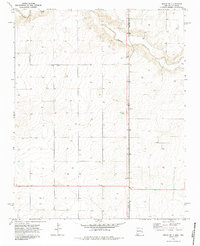
1970 Map of Sedan NE
USGS Topo · Published 1973About this map
Carrizo Creek meanders across the high plains of this borderland territory, where the state line between New Mexico and Texas meets the boundary of Union and Dallam counties. The landscape is defined by its agricultural utility and vast open sections, punctuated by the small settlement at Campsey. A network of ranch roads and fence lines connects numerous water sources, primarily marked as wells, which were essential for sustaining livestock in this arid environment. The map provides a detailed look at the 1970s land use in the region, including industrial evidence such as a Gravel Pit and the precise placement of numerous benchmarks and section corners that served the local ranching community.
Find a feature on this map
6 named features on this map. Tap any name to fly to it.
Don’t see what you’re looking for? This feature index may not catch every label — zoom into the map to look around manually.
Map Details
Editions of this 1970 Sedan NE Map
2 editions found
Other maps of this area

1954 · Dalhart
USGS Topo · 1:250,000

1958 · Dalhart
USGS Topo · 1:250,000

1962 · Dalhart
USGS Topo · 1:250,000

1970 · Stead
USGS Topo · 1:24,000

1970 · Texline South
USGS Topo · 1:24,000

1970 · Clayton SW
USGS Topo · 1:24,000

1970 · Sedan
USGS Topo · 1:24,000

1970 · Sedan SE
USGS Topo · 1:24,000

1973 · Corlena
USGS Topo · 1:24,000
1973 · Windy Hill
USGS Topo · 1:24,000