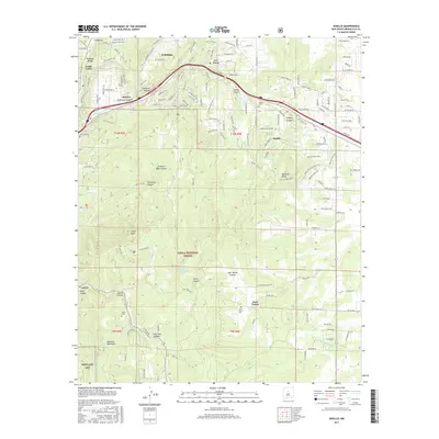
2017 Map of Sedillo
USGS Topo · Published 2017About this map
Cibola National Forest dominates this landscape on the eastern slopes of the Manzano Mountains, where deep drainages like Tijeras Canyon and Gutierrez Canyon carve through the high terrain. The map documents a cluster of small mountain communities and rural developments, including Cedar Crest, Sedillo, and Juan Tomas. These settlements are linked by a network of local roads and the major corridor of Tijeras Arroyo, reflecting the expansion of residential life into the forested canyons east of Albuquerque. For genealogists and local historians, the sheet identifies several remote burial grounds, such as Sedillo Cem, Juan Tomas Cem, and Cedro Cem, which serve as vital markers for family research in these mountain villages. The southern portion includes the northern fringes of Kirtland AFB and the prominent Cedro Peak, showing how military and national forest land usage interfaces with private holdings.
Find a feature on this map
194 named features on this map. Tap any name to fly to it.
Don’t see what you’re looking for? This feature index may not catch every label — zoom into the map to look around manually.
Map Details
Editions of this 2017 Sedillo Map
This is the sole edition of this map. No revisions or reprints were ever made.
Other maps of this area

1892 · San Pedro
USGS Topo · 1:125,000

1917 · Estancia
USGS Topo · 1:125,000

1954 · Sandia Crest
USGS Topo · 1:24,000

1954 · Chilili
USGS Topo · 1:24,000

1954 · Sandia Park
USGS Topo · 1:24,000

1954 · San Pedro
USGS Topo · 1:24,000

1954 · Mount Washington
USGS Topo · 1:24,000
1954 · Tijeras
USGS Topo · 1:24,000

1954 · Sedillo
USGS Topo · 1:24,000

1954 · Escabosa
USGS Topo · 1:24,000