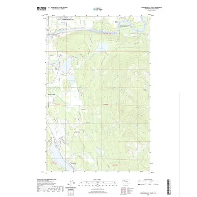
2020 Map of Sedro-Woolley South
USGS Topo · Published 2020About this map
The Skagit Wild and Scenic River dominates the northern reaches of this Skagit County landscape, defining the transition from the valley floor to the rising Cultus Mountains. Downstream from the bend at Skiyou Island, the river flows past Sedro-Woolley, where the Skagit River Bridge serves as a vital crossing point. The southern portion of the map reveals a series of significant water bodies, including the large expanse of Big Lake and the settlement of Montborne along its shores.
Find a feature on this map
86 named features on this map. Tap any name to fly to it.
Don’t see what you’re looking for? This feature index may not catch every label — zoom into the map to look around manually.
Map Details
Editions of this 2020 Sedro-Woolley South Map
This is the sole edition of this map. No revisions or reprints were ever made.
Other maps of this area

1911 · Mount Vernon
USGS Topo · 1:125,000

1918 · Samish Lake
USGS Topo · 1:62,500

1921 · Wickersham
USGS Topo · 1:62,500

1940 · Mt Vernon
USGS Topo · 1:62,500

1943 · Mt Vernon
USGS Topo · 1:62,500

1944 · Clear Lake
USGS Topo · 1:62,500

1951 · Wickersham
USGS Topo · 1:62,500

1952 · Alger
USGS Topo · 1:24,000

1954 · Samish Lake
USGS Topo · 1:62,500
1956 · Clear Lake
USGS Topo · 1:62,500