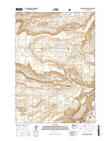
2017 Map of Seekseequa Junction
USGS Topo · Published 2017About this map
Seekseequa Junction serves as a focal point for this high-desert landscape in central Oregon, where the terrain drops sharply toward the eastern canyon of the Deschutes River. This 2017 survey details a region defined by dramatic elevation changes, notably along the Metolius Bench and Tenino Bench, which overlook the winding waters of Lake Simtustus. The area retains its tribal and historic significance with the presence of Seekseequa Cem - 1 and Seekseequa Cem - 2, while natural water sources like Daisy Spring and Pipp Spring dot the landscape. To the southeast, the protected reaches of the Crooked River National Grassland begin to appear, characterized by isolated peaks such as Coyote Butte and the Jackson Buttes. The intricate network of forest and Bureau of Indian Affairs roads, including Bia RD 24 and Metolius Bench Rd, highlights the modern connectivity of these traditionally significant lands.
Find a feature on this map
49 named features on this map. Tap any name to fly to it.
Don’t see what you’re looking for? This feature index may not catch every label — zoom into the map to look around manually.
Map Details
Editions of this 2017 Seekseequa Junction Map
This is the sole edition of this map. No revisions or reprints were ever made.
Other maps of this area

1928 · Madras
USGS Topo · 1:125,000

1931 · Madras
USGS Topo · 1:125,000

1955 · Bend
USGS Topo · 1:250,000

1957 · Bend
USGS Topo · 1:250,000

1958 · Bend
USGS Topo · 1:250,000

1962 · Metolius Bench
USGS Topo · 1:24,000

1962 · Fly Creek
USGS Topo · 1:24,000

1962 · Eagle Butte
USGS Topo · 1:24,000
1962 · Seekseequa Junction
USGS Topo · 1:24,000
1962 · Round Butte Dam
USGS Topo · 1:24,000