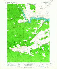
1962 Map of Fly Creek
USGS Topo · Published 1963About this map
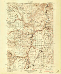
Metolius River canyons and high timbered plateaus define this region of the Deschutes National Forest in the early 1960s. The landscape is dominated by the newly formed Lake Chinook, created behind the Box Canyon Dam. This era shows the transition of the waterways from free-flowing canyons to a managed reservoir system, with the normal pool elevation of the lake carefully noted at 1945 feet. High above the water, remote outposts like Fly Lake Lookout and Fly Creek Ranch provide evidence of forest management and early ranching efforts in the rugged Jefferson County backcountry. The map also captures the stark contrast between the dense forest and the open expanse of the Lower Desert and Metolius Bench. A network of early access routes including the Horse Trap Rd and various jeep trails suggest a period when this area was primarily used for timber, grazing, and fire suppression.
Find a feature on this map
29 named features on this map. Tap any name to fly to it.
Don’t see what you’re looking for? This feature index may not catch every label — zoom into the map to look around manually.
Map Details
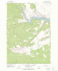
Editions of this 1962 Fly Creek Map
2 editions found
Other maps of this area

1926 · Bend
USGS Topo · 1:125,000
1927 · Mt. Jefferson
USGS Topo · 1:125,000

1928 · Madras
USGS Topo · 1:125,000

1929 · Bend
USGS Topo · 1:125,000

1929 · Three Sisters
USGS Topo · 1:125,000
1930 · Mt. Jefferson
USGS Topo · 1:125,000
1931 · Madras
USGS Topo · 1:125,000

1932 · Three Sisters
USGS Topo · 1:125,000

1955 · Bend
USGS Topo · 1:250,000

1957 · Bend
USGS Topo · 1:250,000