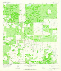
1963 Map of Seeligson Ranch
USGS Topo · Published 1965About this map
The Premont Oil Field and the surrounding South Texas cattle country define this 1963 landscape along the border of Duval and Jim Wells Counties. The map reveals a highly specialized infrastructure designed for resource extraction and ranching, where numerous pipelines and a Pumping Sta intersect with large-scale holdings like Seeligson Ranch and Los Jaboncillos Ranch. The terrain is characterized by a network of drainage systems and watering points essential for livestock, including Jaboncillos Creek and Salado Creek, alongside numerous named tanks and windmills like the Ochenta Windmill and Rincon Windmill. The presence of the Las Piparitas (Site) and a dedicated Landing Strip suggests the logistical complexity of managing these remote operations during the early 1960s. This survey provides a clear view of the regional transition from traditional grazing lands to an integrated energy-producing landscape.
Find a feature on this map
28 named features on this map. Tap any name to fly to it.
Don’t see what you’re looking for? This feature index may not catch every label — zoom into the map to look around manually.
Map Details
Editions of this 1963 Seeligson Ranch Map
This is the sole edition of this map. No revisions or reprints were ever made.
Other maps of this area

1917 · Ben Bolt
USGS Topo · 1:62,500

1921 · Falfurrias
USGS Topo · 1:125,000

1956 · Benavides
USGS Topo · 1:62,500

1956 · Laredo
USGS Topo · 1:250,000

1963 · Ben Bolt SE
USGS Topo · 1:24,000

1963 · Premont West
USGS Topo · 1:24,000
1963 · Premont East
USGS Topo · 1:24,000
1963 · Palito Blanco
USGS Topo · 1:24,000
1963 · Ella
USGS Topo · 1:24,000

1968 · Concepcion
USGS Topo · 1:24,000