
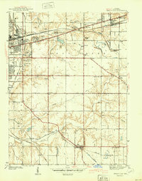
1941 Map of Seelyville
USGS Topo · Published 1941About this map
The eastern edge of Terre Haute transitions into a landscape defined by coal extraction and major transport corridors in this 1939 survey. The Pennsylvania and New York Central railroads cut across the terrain, serving industrial sites like the Binkley Mine and smaller Strip Mine operations. Significant institutional landmarks include the Rose Polytechnic Institute and the Viso County Childrens Home, while the extensive grounds of Highland Lawn Cemetery and Deming Park anchor the suburban fringe.
Find a feature on this map
65 named features on this map. Tap any name to fly to it.
Don’t see what you’re looking for? This feature index may not catch every label — zoom into the map to look around manually.
Map Details
Editions of this 1941 Seelyville Map
2 editions found
Other maps of this area

1908 · Clay City
USGS Topo · 1:48,000

1910 · Clay City
USGS Topo · 1:62,500

1940 · Lewis
USGS Topo · 1:24,000

1940 · Pimento
USGS Topo · 1:24,000

1941 · Terre Haute
USGS Topo · 1:24,000

1948 · Terre Haute
USGS Topo · 1:24,000

1950 · Rosedale
USGS Topo · 1:24,000

1950 · Brazil West
USGS Topo · 1:24,000

1950 · New Goshen
USGS Topo · 1:24,000
1952 · Lewis
USGS Topo · 1:24,000