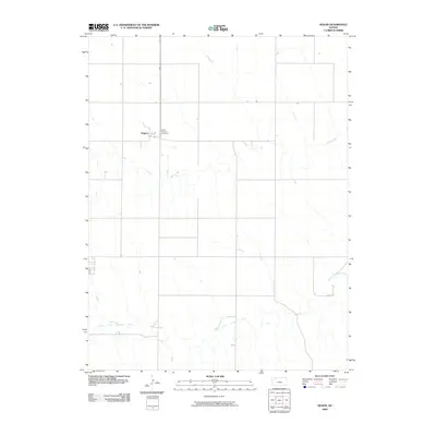
2009 Map of Seguin
USGS Topo · Published 2009About this map
Seguin stands as a quiet settlement on the High Plains of western Kansas, where the landscape is defined by the steady geometry of section-line roads and the winding paths of intermittent waterways. This 2009 survey highlights the local prominence of Saint Martins Cemetery, a critical site for genealogists and local historians tracing family lineages in Sheridan County. The terrain is shaped by the eastward flow of the South Fork Solomon River, which crosses the southern portion of the quadrangle, and the multi-branched Sand Creek to the north. These drainage patterns dictated the original settlement and agricultural layout of the region. The map captures the enduring rural character of the area, showing how the sparse population remains concentrated near these traditional water sources and the established road network.
Find a feature on this map
4 named features on this map. Tap any name to fly to it.
Don’t see what you’re looking for? This feature index may not catch every label — zoom into the map to look around manually.
Map Details
Editions of this 2009 Seguin Map
This is the sole edition of this map. No revisions or reprints were ever made.
Other maps of this area

1954 · Goodland
USGS Topo · 1:250,000

1956 · Goodland
USGS Topo · 1:250,000

1957 · Goodland
USGS Topo · 1:250,000

1979 · Menlo
USGS Topo · 1:24,000

1979 · Midway Draw West
USGS Topo · 1:24,000

1979 · Rexford
USGS Topo · 1:24,000

1979 · Hoxie
USGS Topo · 1:24,000
1979 · Rexford NE
USGS Topo · 1:24,000

1979 · Grinnell NE
USGS Topo · 1:24,000
1979 · Grinnell North
USGS Topo · 1:24,000