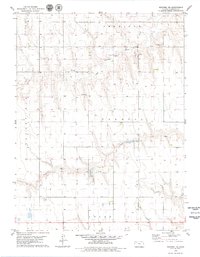
1979 Map of Rexford NE
USGS Topo · Published 1979About this map
The North Fork Solomon River meanders across this rural Sheridan County landscape, where agriculture and resource extraction define the local economy during the late 1970s. This survey area captures the intersection of three distinct local jurisdictions: Sheridan, Parnell, and Logan. The land is predominantly defined by its natural drainage, with the South Bow Creek carving through the southern half of the quadrangle. Human activity is marked by a significant Feedlot and several Gravel Pits, alongside a network of section roads and scattered wells. The presence of an Oil Well and multiple Sandpits along the riverbanks indicates the industrial use of the terrain in areas like Bloomfield and Prairie Dog.
Find a feature on this map
12 named features on this map. Tap any name to fly to it.
Don’t see what you’re looking for? This feature index may not catch every label — zoom into the map to look around manually.
Map Details
Editions of this 1979 Rexford NE Map
This is the sole edition of this map. No revisions or reprints were ever made.
Other maps of this area

1951 · Selden
USGS Topo · 1:62,500

1954 · Goodland
USGS Topo · 1:250,000

1956 · Goodland
USGS Topo · 1:250,000

1957 · Goodland
USGS Topo · 1:250,000

1978 · Selden
USGS Topo · 1:24,000

1978 · Selden SW
USGS Topo · 1:24,000

1978 · Dresden South
USGS Topo · 1:24,000

1979 · Menlo
USGS Topo · 1:24,000

1979 · Rexford
USGS Topo · 1:24,000

1979 · Hoxie
USGS Topo · 1:24,000