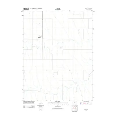
2012 Map of Seguin
USGS Topo · Published 2012About this map
Seguin remains a quiet prairie settlement in Sheridan County on this 2012 survey, centered around the Saint Martins Cem. The landscape is defined by the high plains drainage patterns of the S Fork Solomon River and Sand Cr, which cut through the agricultural grid. A network of rural section roads, including Road 80W, provides the primary transit framework across this sparsely populated section of Kansas. The proximity of the cemetery to the small cluster of buildings in Seguin highlights the community's local history and persistent presence in the Western Kansas landscape.
Find a feature on this map
5 named features on this map. Tap any name to fly to it.
Don’t see what you’re looking for? This feature index may not catch every label — zoom into the map to look around manually.
Map Details
Editions of this 2012 Seguin Map
This is the sole edition of this map. No revisions or reprints were ever made.
Other maps of this area

1954 · Goodland
USGS Topo · 1:250,000

1956 · Goodland
USGS Topo · 1:250,000

1957 · Goodland
USGS Topo · 1:250,000

1979 · Menlo
USGS Topo · 1:24,000

1979 · Midway Draw West
USGS Topo · 1:24,000

1979 · Rexford
USGS Topo · 1:24,000

1979 · Hoxie
USGS Topo · 1:24,000
1979 · Rexford NE
USGS Topo · 1:24,000

1979 · Grinnell NE
USGS Topo · 1:24,000
1979 · Grinnell North
USGS Topo · 1:24,000