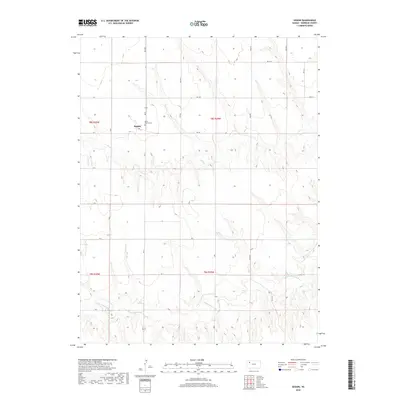
2018 Map of Seguin
USGS Topo · Published 2018About this map
Seguin serves as the primary focal point of this Sheridan County landscape, situated amidst the high plains where the township lines of t8s r30w, t8s r29w, t9s r30w, and t9s r29w converge. The settlement pattern is defined by a rigid grid of section roads, including RD 10 N and RD 20 S, which facilitate transit across the agricultural terrain. To the east of the townsite, Saint Martins Cem provides a specific point of interest for genealogists and local historians, anchoring the community's heritage in the northwestern Kansas prairie. The topography is shaped by the drainage systems of Sand Cr and the S Fork Solomon River, which cut distinct paths through the otherwise level elevation. These watercourses were foundational to the early organization of the county, influencing road placement and the location of rural landmarks.
Find a feature on this map
18 named features on this map. Tap any name to fly to it.
Don’t see what you’re looking for? This feature index may not catch every label — zoom into the map to look around manually.
Map Details
Editions of this 2018 Seguin Map
This is the sole edition of this map. No revisions or reprints were ever made.
Other maps of this area

1954 · Goodland
USGS Topo · 1:250,000

1956 · Goodland
USGS Topo · 1:250,000

1957 · Goodland
USGS Topo · 1:250,000

1979 · Menlo
USGS Topo · 1:24,000

1979 · Midway Draw West
USGS Topo · 1:24,000

1979 · Rexford
USGS Topo · 1:24,000

1979 · Hoxie
USGS Topo · 1:24,000
1979 · Rexford NE
USGS Topo · 1:24,000

1979 · Grinnell NE
USGS Topo · 1:24,000
1979 · Grinnell North
USGS Topo · 1:24,000