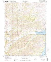
1967 Map of Sehorn Creek
USGS Topo · Published 1977About this map
Elmore Cemetery sits above the winding drainages that define this portion of the Sacramento Valley foothills during the mid-1960s. The landscape is characterized by a complex network of seasonal and perennial waterways including Sehorn Creek, Elmore Creek, and Parker Creek, which carve through the terrain toward the southern focal point of Black Butte Lake. This reservoir, showing a spillway elevation of 474 feet, dominates the southeastern quadrant where the Tehama and Glenn County line bisects the water.
Find a feature on this map
23 named features on this map. Tap any name to fly to it.
Don’t see what you’re looking for? This feature index may not catch every label — zoom into the map to look around manually.
Map Details
Editions of this 1967 Sehorn Creek Map
3 editions found
Other maps of this area

1904 · Walker Creek
USGS Topo · 1:31,680

1919 · Fruto
USGS Topo · 1:62,500

1919 · Elk Creek
USGS Topo · 1:62,500

1944 · Fruto
USGS Topo · 1:62,500

1944 · Flournoy
USGS Topo · 1:62,500

1948 · Elk Creek
USGS Topo · 1:62,500
1952 · Fruto NE
USGS Topo · 1:24,000

1952 · Paskenta
USGS Topo · 1:62,500

1957 · Elk Creek
USGS Topo · 1:62,500

1957 · Ukiah
USGS Topo · 1:250,000