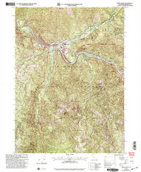
2001 Map of Seiad Valley
USGS Topo · Published 2004About this map
Seiad Valley sits at a critical junction of the Klamath River and the high ridges of the Klamath National Forest. This survey, revised by the Forest Service at the turn of the 21st century, details a landscape defined by its river-bottom resources and steep mountain drainages. The presence of tailings near the riverbanks and along Seiad Creek indicates the enduring legacy of gold mining in this part of Siskiyou County. The small community is centered around the Seiad Work Center and the Grider Creek Ranch, which occupy the narrow arable lands below Lower Devils Peak. The map illustrates the complex topography of the region, from the Klamath River Wild and Scenic Road following the water's edge to the high summits of Baldy Mountain and Blue Mountain. Numerous drainages like Portuguese Creek and Williams Gulch feed into the main river system, carving deep into the forest terrain.
Find a feature on this map
34 named features on this map. Tap any name to fly to it.
Don’t see what you’re looking for? This feature index may not catch every label — zoom into the map to look around manually.
Map Details
Editions of this 2001 Seiad Valley Map
This is the sole edition of this map. No revisions or reprints were ever made.
Other maps of this area

1914 · Seiad
USGS Topo · 1:125,000

1922 · Seiad
USGS Topo · 1:125,000

1948 · Weed
USGS Topo · 1:250,000

1950 · Weed
USGS Topo · 1:250,000

1955 · Seiad Valley
USGS Topo · 1:62,500

1955 · Ukonom Lake
USGS Topo · 1:62,500

1955 · Scott Bar
USGS Topo · 1:62,500

1956 · Happy Camp
USGS Topo · 1:62,500

1958 · Weed
USGS Topo · 1:250,000

1963 · Weed
USGS Topo · 1:250,000