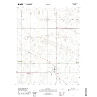
2018 Map of Seiling
USGS Topo · Published 2018About this map
Seiling serves as the primary hub for this portion of the Oklahoma plains, situated near the intersection of several regional highways and the North Canadian River. The town's grid is well-defined by streets such as N Oak St and N Elm St, supported by the nearby Seiling Airport and Brumfield Cem. The surrounding rural landscape reflects a pattern of section-line roads and dispersed settlements like Chester to the north.
Find a feature on this map
48 named features on this map. Tap any name to fly to it.
Don’t see what you’re looking for? This feature index may not catch every label — zoom into the map to look around manually.
Map Details
Editions of this 2018 Seiling Map
This is the sole edition of this map. No revisions or reprints were ever made.
Other maps of this area

1955 · Woodward
USGS Topo · 1:250,000

1958 · Woodward
USGS Topo · 1:250,000

1969 · Mooreland SE
USGS Topo · 1:24,000

1969 · Phroso
USGS Topo · 1:24,000

1969 · Cedardale
USGS Topo · 1:24,000

1969 · Lenora
USGS Topo · 1:24,000

1969 · Mutual NE
USGS Topo · 1:24,000

1972 · Hucmac
USGS Topo · 1:24,000

1972 · Seiling
USGS Topo · 1:24,000
1972 · Taloga
USGS Topo · 1:24,000