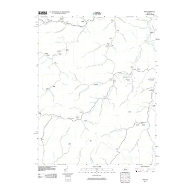
2010 Map of Seitz
USGS Topo · Published 2010About this map
The Right Fork Licking River carves through this part of Breathitt County, anchoring a landscape where small settlements like Seitz, Fritz, and Foraker follow the narrow valley floors. The mapping reveals a distinct pattern of family-named land use and genealogy, particularly through its high density of small family burial grounds. Notable sites include the William Big Bill Patriotic Cemetery in the north and the Ambrose and Susan Arnett Cemetery to the east. These small, scattered cemeteries, along with locations like Arnett Hollow and Bunker Bottom Flat, suggest a long-standing kinship network tied to specific creeks and hollows. Transport in the area is defined by winding rural routes such as Stevens Branch Rd and the Seitz-Spruce Pine Branch Rd, which navigate the complex drainage systems of Johnson Creek and Puncheon Creek.
Find a feature on this map
114 named features on this map. Tap any name to fly to it.
Don’t see what you’re looking for? This feature index may not catch every label — zoom into the map to look around manually.
Map Details
Editions of this 2010 Seitz Map
This is the sole edition of this map. No revisions or reprints were ever made.
Other maps of this area

1889 · Salyersville
USGS Topo · 1:125,000

1891 · Salyersville
USGS Topo · 1:125,000

1899 · Salyersville
USGS Topo · 1:125,000

1951 · Tiptop
USGS Topo · 1:24,000

1951 · Cannel City
USGS Topo · 1:24,000

1951 · Guage
USGS Topo · 1:24,000

1951 · White Oak
USGS Topo · 1:24,000
1951 · Salyersville North
USGS Topo · 1:24,000

1951 · Seitz
USGS Topo · 1:24,000

1951 · Quicksand
USGS Topo · 1:24,000