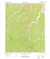
1965 Map of Seitz
USGS Topo · Published 1978About this map
Seitz sits at the heart of this mid-1960s study, a time when the rural landscape of Magoffin County was defined by its intricate hollows and early extractive industry. The area is heavily intersected by the Mountain Parkway and associated Toll Road, which cut through the steep terrain near Johnson Mountain. This survey reveals a high density of local institutions, including the Puncheon Sch, Cutuno School, and Wagers Sch, reflecting a settled population dispersed along the forks of the Licking River and Wolf Creek. Genealogy resources are abundant, with family-named landmarks like Arnett Hollow and several small burial grounds such as Rudd Cem and Walters Cem located near the headwaters of various branches. The presence of a Strip Mine and multiple scattered Mines signals the region's historical reliance on coal, while churches like Zion Ch and Samaria Ch served as central community anchors in the narrow valleys.
Find a feature on this map
95 named features on this map. Tap any name to fly to it.
Don’t see what you’re looking for? This feature index may not catch every label — zoom into the map to look around manually.
Map Details
Editions of this 1965 Seitz Map
2 editions found
Other maps of this area

1889 · Salyersville
USGS Topo · 1:125,000

1891 · Salyersville
USGS Topo · 1:125,000

1899 · Salyersville
USGS Topo · 1:125,000

1951 · Tiptop
USGS Topo · 1:24,000

1951 · Cannel City
USGS Topo · 1:24,000

1951 · Guage
USGS Topo · 1:24,000

1951 · White Oak
USGS Topo · 1:24,000
1951 · Salyersville North
USGS Topo · 1:24,000

1951 · Seitz
USGS Topo · 1:24,000

1951 · Quicksand
USGS Topo · 1:24,000