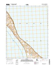
2016 Map of Selawik C-6 SW
USGS Topo · Published 2016About this map
Baldwin Peninsula forms a narrow terrestrial finger between two major arctic waterways on this 2016 survey. This thin strip of land serves as a natural barrier, separating the brackish waters of Hotham Inlet to the east from the open marine environment of Kotzebue Sound to the west. The topography is characterized by low-elevation coastal tundra and a complex network of small wetlands and drainage patterns. The map highlights the shifting interface of land and sea in the Northwest Arctic Borough, where the peninsula's coastline is the primary geographic driver of local navigation and environmental character. This specific section of the peninsula exhibits the transition from the marine-influenced western shores to the more sheltered waters of the inlet, providing a detailed look at the hydrology of this sub-arctic coastal landform.
Find a feature on this map
7 named features on this map. Tap any name to fly to it.
Don’t see what you’re looking for? This feature index may not catch every label — zoom into the map to look around manually.
Map Details
Editions of this 2016 Selawik C-6 SW Map
This is the sole edition of this map. No revisions or reprints were ever made.
Other maps of this area

1951 · Selawik
USGS Topo · 1:250,000

1951 · Kotzebue
USGS Topo · 1:250,000

1951 · Selawik C-6
USGS Topo · 1:63,360

1951 · Selawik B-6
USGS Topo · 1:63,360
1951 · Kotzebue C-1
USGS Topo · 1:63,360

1957 · Selawik
USGS Topo · 1:250,000

1958 · Kotzebue
USGS Topo · 1:250,000

1964 · Kotzebue
USGS Topo · 1:250,000
2016 · Selawik C-6 NE
USGS Topo · 1:25,000
2016 · Selawik B-6 NW
USGS Topo · 1:25,000