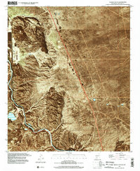
1996 Map of Selden Canyon
USGS Topo · Published 2002About this map
The Rio Grande snakes through the southwestern corner of this quadrangle, carving the deep passage of Selden Canyon through the desert floor. This landscape is defined by the stark contrast between the fertile Rincon Valley and the surrounding high desert, dominated by landmarks like Tonuco Mountain and Cedar Hill. The expansive New Mexico State University Animal Science Ranch occupies a significant portion of the central plateau, illustrating the region's long-standing connection to academic research and livestock management in arid environments.
Find a feature on this map
59 named features on this map. Tap any name to fly to it.
Don’t see what you’re looking for? This feature index may not catch every label — zoom into the map to look around manually.
Map Details
Editions of this 1996 Selden Canyon Map
This is the sole edition of this map. No revisions or reprints were ever made.
Other maps of this area

1891 · Las Cruces
USGS Topo · 1:125,000

1893 · Las Cruces
USGS Topo · 1:125,000

1916 · Tonuco
USGS Topo · 1:125,000

1932 · Tonuco
USGS Topo · 1:125,000

1941 · Las Cruces
USGS Topo · 1:62,500

1943 · Corralitos Ranch
USGS Topo · 1:62,500

1943 · Las Cruces
USGS Topo · 1:62,500

1948 · San Diego Mountain
USGS Topo · 1:62,500

1955 · Las Cruces
USGS Topo · 1:250,000

1958 · Las Cruces
USGS Topo · 1:250,000