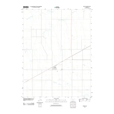
2009 Map of Selden
USGS Topo · Published 2009About this map
Selden serves as the primary hub of this Sheridan County landscape, situated at the intersection of significant transit corridors. The town’s orderly street grid and the nearby Selden Cemetery reflect the long-standing agricultural community established in this high plains region. The terrain is defined by the drainage systems of Prairie Dog Creek and its north fork, which carve subtle paths across the prairie. In the southeastern corner, the North Fork Solomon River crosses the landscape, marking a vital hydrological feature for the local ecology. Local infrastructure is represented by routes like Co Rd 370, which connect the town to the surrounding rural sections. The map illustrates a traditional Kansas settlement pattern where the town center remains closely tied to the natural watercourses that once guided early pioneers and later farmers through the county.
Find a feature on this map
6 named features on this map. Tap any name to fly to it.
Don’t see what you’re looking for? This feature index may not catch every label — zoom into the map to look around manually.
Map Details
Editions of this 2009 Selden Map
This is the sole edition of this map. No revisions or reprints were ever made.
Other maps of this area

1951 · Selden
USGS Topo · 1:62,500

1954 · Goodland
USGS Topo · 1:250,000

1956 · Goodland
USGS Topo · 1:250,000

1957 · Goodland
USGS Topo · 1:250,000

1965 · Selden NW
USGS Topo · 1:24,000
1965 · Selden NE
USGS Topo · 1:24,000
1978 · Dresden North
USGS Topo · 1:24,000

1978 · Selden
USGS Topo · 1:24,000

1978 · Selden SW
USGS Topo · 1:24,000

1978 · Dresden South
USGS Topo · 1:24,000