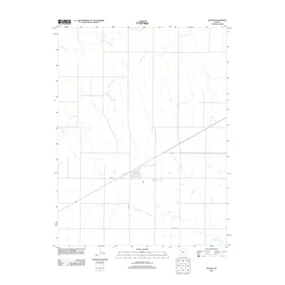
2012 Map of Selden
USGS Topo · Published 2012About this map
Selden is the primary settlement on this western Kansas landscape, positioned where several regional transportation routes intersect in Sheridan County. The town layout is clearly defined by local thoroughfares including 6th St and Road 364, with the central Po serving as a community hub. Local history and genealogy interests are anchored by the Selden Cem, located just southeast of the town center. The surrounding terrain is defined by its drainage systems, most notably the meandering paths of Prairie Dog Cr and its northern branch, N Fork Prairie Dog Cr, which carve through the plains. In the southeastern corner of the sheet, the N Fork Solomon River appears, signaling the headwaters of a major river system that historically influenced the development of the region's agricultural and rural road networks, such as Co Rd-370 and Co Rd-481.
Find a feature on this map
9 named features on this map. Tap any name to fly to it.
Don’t see what you’re looking for? This feature index may not catch every label — zoom into the map to look around manually.
Map Details
Editions of this 2012 Selden Map
This is the sole edition of this map. No revisions or reprints were ever made.
Other maps of this area

1951 · Selden
USGS Topo · 1:62,500

1954 · Goodland
USGS Topo · 1:250,000

1956 · Goodland
USGS Topo · 1:250,000

1957 · Goodland
USGS Topo · 1:250,000

1965 · Selden NW
USGS Topo · 1:24,000
1965 · Selden NE
USGS Topo · 1:24,000
1978 · Dresden North
USGS Topo · 1:24,000

1978 · Selden
USGS Topo · 1:24,000

1978 · Selden SW
USGS Topo · 1:24,000

1978 · Dresden South
USGS Topo · 1:24,000