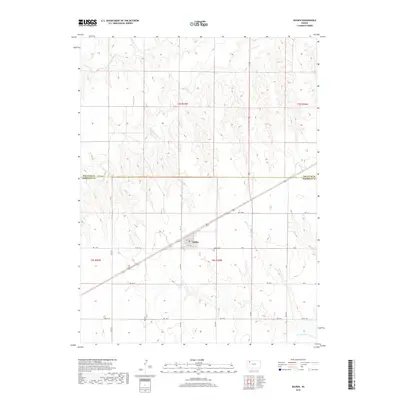
2018 Map of Selden
USGS Topo · Published 2018About this map
Selden serves as the central hub of this Sheridan County landscape, where a grid of local roads and streets like Main St and 5th St meet the primary highway. The town's layout reflects the high plains' methodical section-line development, situated just south of the Decatur County and Sheridan County border. This 2018 survey reveals a terrain defined by the subtle drainage systems of the Prairie Dog Creek watershed in the north and the North Fork Solomon River at the extreme southern edge. Genealogists and local researchers will find the Selden Cemetery located just east of the main settlement, providing a specific point of interest for family history. The surrounding acreage is interconnected by an extensive network of numbered rural routes, including Rd 140 N and Rd 110 N, which trace the agricultural divisions of the region.
Find a feature on this map
21 named features on this map. Tap any name to fly to it.
Don’t see what you’re looking for? This feature index may not catch every label — zoom into the map to look around manually.
Map Details
Editions of this 2018 Selden Map
This is the sole edition of this map. No revisions or reprints were ever made.
Other maps of this area

1951 · Selden
USGS Topo · 1:62,500

1954 · Goodland
USGS Topo · 1:250,000

1956 · Goodland
USGS Topo · 1:250,000

1957 · Goodland
USGS Topo · 1:250,000

1965 · Selden NW
USGS Topo · 1:24,000
1965 · Selden NE
USGS Topo · 1:24,000
1978 · Dresden North
USGS Topo · 1:24,000

1978 · Selden
USGS Topo · 1:24,000

1978 · Selden SW
USGS Topo · 1:24,000

1978 · Dresden South
USGS Topo · 1:24,000