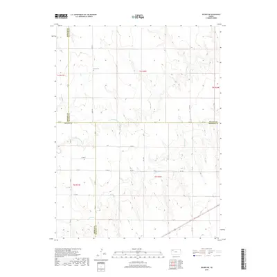
2018 Map of Selden SW
USGS Topo · Published 2018About this map
The Hawkeye Cem stands as a focal point for genealogical interest in this rural landscape, situated near the intersection of several county lines in northwest Kansas. This 2018 survey reveals a terrain defined by the headwaters of the N Fork Prairie Dog Cr and Prairie Dog Cr, which carve a network of draws and ridges through the high plains. The map captures the meeting point of four counties: Rawlins Co, Decatur Co, Sheridan Co, and Thomas Co. The land is organized by a precise grid of rural routes, including Co RD 459 and Co RD Ee, illustrating the enduring sectional survey system that dictates the placement of farms and cemeteries in the region. This document is essential for those tracing the agricultural development and land ownership patterns where these four counties converge.
Find a feature on this map
31 named features on this map. Tap any name to fly to it.
Don’t see what you’re looking for? This feature index may not catch every label — zoom into the map to look around manually.
Map Details
Editions of this 2018 Selden SW Map
This is the sole edition of this map. No revisions or reprints were ever made.
Other maps of this area

1951 · Selden
USGS Topo · 1:62,500

1951 · Achilles
USGS Topo · 1:62,500

1954 · Goodland
USGS Topo · 1:250,000

1956 · Goodland
USGS Topo · 1:250,000

1957 · Goodland
USGS Topo · 1:250,000

1965 · Achilles
USGS Topo · 1:24,000

1965 · Selden NW
USGS Topo · 1:24,000
1965 · Selden NE
USGS Topo · 1:24,000

1978 · Selden
USGS Topo · 1:24,000

1978 · Achilles SE
USGS Topo · 1:24,000