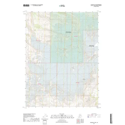
2018 Map of Seldovia B-3 NW
USGS Topo · Published 2018About this map
The Wosnesenski River valley defines the glacial and hydrological character of this portion of the Kenai Peninsula. Modern land management boundaries are the primary human overlay on this remote terrain, as the map shows the transition between the Kenai National Wildlife Refuge and Kenai Fjords National Park. These federal designations reflect a landscape preserved for its natural state, dominated by the peaks of the Kenai Mountains. The topography recorded here, compiled from data including 2010 imagery and 2017 elevation datasets, illustrates a high-altitude wilderness where natural drainage patterns and mountain ridges are the sole landmarks. This 2018 survey captures a snapshot of the region's protected status and the enduring physical geography of the Kenai Mountains range.
Find a feature on this map
1 named feature on this map. Tap any name to fly to it.
Don’t see what you’re looking for? This feature index may not catch every label — zoom into the map to look around manually.
Map Details
Editions of this 2018 Seldovia B-3 NW Map
This is the sole edition of this map. No revisions or reprints were ever made.
Other maps of this area

1948 · Seldovia C-4
USGS Topo · 1:63,360

1949 · Seldovia C-4
USGS Topo · 1:62,500

1951 · Seldovia
USGS Topo · 1:250,000

1951 · Seldovia B-4
USGS Topo · 1:63,360

1951 · Seldovia B-3
USGS Topo · 1:63,360

1951 · Seldovia C-3
USGS Topo · 1:63,360

1952 · Seldovia B-3
USGS Topo · 1:63,360

1953 · Seldovia C-3
USGS Topo · 1:63,360

1953 · Seldovia B-4
USGS Topo · 1:63,360
1961 · Seldovia C-4
USGS Topo · 1:63,360