
1948 Map of Seldovia C-4
USGS Topo · Published 1955About this map
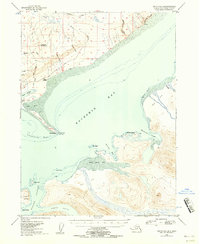
Kachemak Bay dominates this mid-century topographic record, showing the Kenai Peninsula coastline during a period of transition in the late 1940s. The long reach of the Homer Spit terminates at Coal Point, where the Homer Light and Homer East Base provided essential navigational markers for vessels entering the inner bay. Near the base of the spit, the Homer Airport and a Sawmill reflect the post-war development of the area's transportation and timber infrastructure. Across the water, the landscape is defined by deep inlets like Sadie Cove and the intricate shoreline of Halibut Cove, anchored by Ismailof Island. To the north, the terrain rises sharply toward Lookout Mountain, dissected by steep drainages such as McNeil Canyon Creek and Waterman Canyon. Small coastal settlements like Millers Landing and early resource extraction sites marked Coal indicate the early industrial footprint on this maritime environment.
Find a feature on this map
46 named features on this map. Tap any name to fly to it.
Don’t see what you’re looking for? This feature index may not catch every label — zoom into the map to look around manually.
Map Details
Editions of this 1948 Seldovia C-4 Map
2 editions found
Other maps of this area

1946 · Seldovia C-5
USGS Topo · 1:63,360

1946 · Seldovia D-5
USGS Topo · 1:63,360

1949 · Seldovia C-4
USGS Topo · 1:62,500

1949 · Seldovia D-4
USGS Topo · 1:63,360

1951 · Seldovia C-5
USGS Topo · 1:63,360

1951 · Seldovia D-5
USGS Topo · 1:63,360

1951 · Seldovia D-4
USGS Topo · 1:63,360

1951 · Seldovia
USGS Topo · 1:250,000

1951 · Seldovia D-3
USGS Topo · 1:63,360

1951 · Seldovia B-5
USGS Topo · 1:63,360