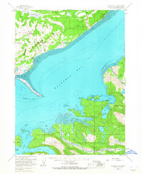
1961 Map of Seldovia C-4
USGS Topo · Published 1967About this map
Homer and its distinctive Homer Spit anchor the northwestern shore of Kachemak Bay in this early 1960s coastal survey. The settlement of Wade and Millers Landing show the established footprint of the Kenai Peninsula before widespread modern expansion, while the Homer Airport and nearby radio towers mark the era's critical transportation and communication links. The map reveals a maritime-focused landscape where Coal Bay and Beluga Lake sit just inland from the active shoreline at Coal Point.
Find a feature on this map
57 named features on this map. Tap any name to fly to it.
Don’t see what you’re looking for? This feature index may not catch every label — zoom into the map to look around manually.
Map Details
Editions of this 1961 Seldovia C-4 Map
3 editions found
Other maps of this area

1946 · Seldovia C-5
USGS Topo · 1:63,360

1946 · Seldovia D-5
USGS Topo · 1:63,360

1948 · Seldovia C-4
USGS Topo · 1:63,360

1949 · Seldovia C-4
USGS Topo · 1:62,500

1949 · Seldovia D-4
USGS Topo · 1:63,360

1951 · Seldovia C-5
USGS Topo · 1:63,360

1951 · Seldovia D-5
USGS Topo · 1:63,360

1951 · Seldovia D-4
USGS Topo · 1:63,360

1951 · Seldovia
USGS Topo · 1:250,000

1951 · Seldovia D-3
USGS Topo · 1:63,360