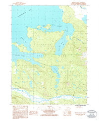
1987 Map of Seldovia C-4 SE
USGS Topo · Published 1987About this map
Kachemak State Park defines the southern shores of Kachemak Bay, where glacial waters and intricate coastlines create a complex maritime landscape. Centered around Halibut Cove and the protected waters of Halibut Cove Lagoon, the terrain reflects a mix of wilderness and small-scale infrastructure. A Landing Strip, Pier, and Dock on Ismailof Island serve as vital transportation nodes for this roadless area, connected by The Narrows to the larger bay. Deep inlets like Peterson Bay and China Poot Bay cut into the mainland, leading to interior features such as China Poot Lake. The southern drainage is dominated by Stonehocker Creek, while Grewingk Creek enters the bay to the northeast. This 1987 provisional survey provides an essential look at the Kenai Peninsula’s coastal topography before modern development altered these remote access points.
Find a feature on this map
19 named features on this map. Tap any name to fly to it.
Don’t see what you’re looking for? This feature index may not catch every label — zoom into the map to look around manually.
Map Details
Editions of this 1987 Seldovia C-4 SE Map
This is the sole edition of this map. No revisions or reprints were ever made.
Other maps of this area

1948 · Seldovia C-4
USGS Topo · 1:63,360

1949 · Seldovia C-4
USGS Topo · 1:62,500

1951 · Seldovia
USGS Topo · 1:250,000

1951 · Seldovia B-4
USGS Topo · 1:63,360

1951 · Seldovia B-3
USGS Topo · 1:63,360

1951 · Seldovia C-3
USGS Topo · 1:63,360

1952 · Seldovia B-3
USGS Topo · 1:63,360

1953 · Seldovia C-3
USGS Topo · 1:63,360

1953 · Seldovia B-4
USGS Topo · 1:63,360
1961 · Seldovia C-4
USGS Topo · 1:63,360