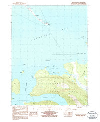
1987 Map of Seldovia C-4 SW
USGS Topo · Published 1987About this map
Homer Spit extends deep into the waters of Kachemak Bay, terminating at Coal Point where a pier serves as a vital maritime link. This 1980s-era topographical study captures the coastal complexity of the Kenai Peninsula, where the waters of Eldred Passage and Sadie Cove wrap around significant landforms like Yukon Island and Hesketh Island. Much of the southern landmass is protected within the Kachemak Bay State Park, a landscape defined by steep elevation changes and drainage systems like Stonehocker Creek. Marine navigation and utility infrastructure are noted by an Underwater Trans Line crossing the bay toward China Poot Bay. Coastal features such as Mc Keon Flats and the rocky outcrops of Lancashire Rocks highlight the tidal and geological transition between the open bay and the interior wilderness.
Find a feature on this map
26 named features on this map. Tap any name to fly to it.
Don’t see what you’re looking for? This feature index may not catch every label — zoom into the map to look around manually.
Map Details
Editions of this 1987 Seldovia C-4 SW Map
This is the sole edition of this map. No revisions or reprints were ever made.
Other maps of this area

1946 · Seldovia C-5
USGS Topo · 1:63,360

1948 · Seldovia C-4
USGS Topo · 1:63,360

1949 · Seldovia C-4
USGS Topo · 1:62,500

1951 · Seldovia C-5
USGS Topo · 1:63,360

1951 · Seldovia
USGS Topo · 1:250,000

1951 · Seldovia B-5
USGS Topo · 1:63,360

1951 · Seldovia B-4
USGS Topo · 1:63,360

1953 · Seldovia B-4
USGS Topo · 1:63,360

1953 · Seldovia B-5
USGS Topo · 1:63,360

1961 · Seldovia C-5
USGS Topo · 1:63,360