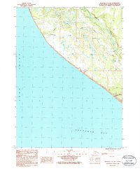
1987 Map of Seldovia C-5 NW
USGS Topo · Published 1987About this map
Anchor River winds through the Kenai Peninsula landscape toward its mouth at Kachemak Bay in this 1980s-era topographic study. The coastal terrain is defined by the sharp intersection of the peninsula with Cook Inlet, where drainage features like Troublesome Creek and Travers Creek cut toward the shoreline. Inland, the Old Sterling Highway follows the contours of the land, providing access to the Anchor River Campground and various Gravel Pit operations that suggest local infrastructure development. To the south, the coastal bluffs drop away at Diamond Gulch, while smaller water bodies like Lilly Lake dot the marshy lowlands, reflecting the characteristic hydrology of the region before further modern expansion. This map captures the intersection of industrial utility and wilderness recreation along the western edge of the borough.
Find a feature on this map
12 named features on this map. Tap any name to fly to it.
Don’t see what you’re looking for? This feature index may not catch every label — zoom into the map to look around manually.
Map Details
Editions of this 1987 Seldovia C-5 NW Map
This is the sole edition of this map. No revisions or reprints were ever made.
Other maps of this area

1946 · Seldovia C-5
USGS Topo · 1:63,360

1946 · Seldovia D-5
USGS Topo · 1:63,360

1951 · Seldovia C-5
USGS Topo · 1:63,360

1951 · Seldovia D-5
USGS Topo · 1:63,360

1951 · Seldovia
USGS Topo · 1:250,000

1961 · Seldovia C-5
USGS Topo · 1:63,360
1961 · Seldovia D-5
USGS Topo · 1:63,360

1963 · Seldovia
USGS Topo · 1:250,000
1987 · Seldovia D-5 SE
USGS Topo · 1:25,000
1987 · Seldovia C-5 NE
USGS Topo · 1:25,000