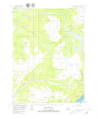
1961 Map of Seldovia D-4
USGS Topo · Published 1980About this map
Ninilchik Dome and the Caribou Hills define the upland geography of this Kenai Peninsula region during the early 1960s. The landscape is dominated by a complex network of watercourses, including the South Fork Anchor River and the headwaters of Stariski Creek. The survey reveals a wilderness mostly accessible via a Tractor Trail that winds through the southwestern corner, reflecting the remote nature of the terrain before extensive modern infrastructure. Notable landmarks such as Center Plateau and Bald Mountain provide significant vertical relief above the plateau. To the southeast, several small lakes like Eagle Lake, Packwood Lake, and Snowshoe Lake cluster near the headwaters of Falls Creek. The southern edge of the map briefly touches the coastline at Kachemak Bay, where Cottonwood Cr and McNeil Cr meet the sea, illustrating the transition from the high interior hills to the maritime environment of the Cook Inlet area.
Find a feature on this map
26 named features on this map. Tap any name to fly to it.
Don’t see what you’re looking for? This feature index may not catch every label — zoom into the map to look around manually.
Map Details
Editions of this 1961 Seldovia D-4 Map
3 editions found
Other maps of this area

1944 · Kenai
USGS Topo · 1:250,000

1946 · Seldovia C-5
USGS Topo · 1:63,360

1946 · Seldovia D-5
USGS Topo · 1:63,360

1948 · Seldovia C-4
USGS Topo · 1:63,360

1949 · Seldovia C-4
USGS Topo · 1:62,500

1949 · Seldovia D-4
USGS Topo · 1:63,360

1950 · Kenai
USGS Topo · 1:250,000

1951 · Seldovia C-5
USGS Topo · 1:63,360

1951 · Seldovia D-5
USGS Topo · 1:63,360

1951 · Seldovia D-4
USGS Topo · 1:63,360