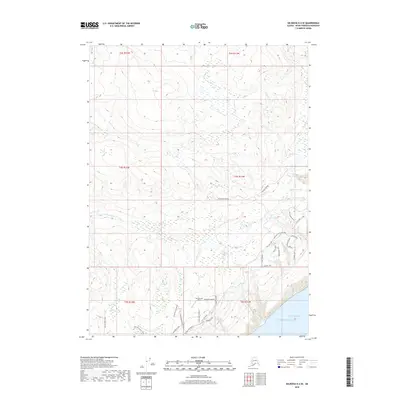
2018 Map of Seldovia D-4 SE
USGS Topo · Published 2018About this map
Kachemak Bay meets the southern coast of the Kenai Peninsula in this 2018 survey, where the topography rises from the Pacific Ocean into a complex network of wetlands and small lakes. The area is defined by its drainage systems, including the Anchor River, McNeil Cr, and S Fork Deep Cr, which carve through the terrain north of the bay. A concentration of residential and bush-access infrastructure is visible along the southern portion of the map, particularly around the Glacierview Strip and a dense network of local roads. These routes, such as Moonbeam Lane, Neolan Drive, and Big Dipper Ranch Road, indicate the modern residential expansion and small-scale aviation dependency characteristic of this part of Alaska. Further inland, the landscape remains largely dominated by water bodies like Eagle Lake, Packwood Lake, and Snowshoe Lake.
Find a feature on this map
43 named features on this map. Tap any name to fly to it.
Don’t see what you’re looking for? This feature index may not catch every label — zoom into the map to look around manually.
Map Details
Editions of this 2018 Seldovia D-4 SE Map
This is the sole edition of this map. No revisions or reprints were ever made.
Other maps of this area

1948 · Seldovia C-4
USGS Topo · 1:63,360

1949 · Seldovia C-4
USGS Topo · 1:62,500

1949 · Seldovia D-4
USGS Topo · 1:63,360

1951 · Seldovia D-4
USGS Topo · 1:63,360

1951 · Seldovia
USGS Topo · 1:250,000

1951 · Seldovia D-3
USGS Topo · 1:63,360

1951 · Seldovia C-3
USGS Topo · 1:63,360

1953 · Seldovia C-3
USGS Topo · 1:63,360
1953 · Seldovia D-3
USGS Topo · 1:63,360
1961 · Seldovia C-4
USGS Topo · 1:63,360