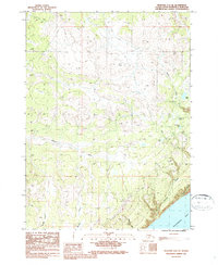
1987 Map of Seldovia D-4 SE
USGS Topo · Published 1987About this map
The Anchor River flows across this Kenai Peninsula landscape as it appeared in the late 1980s, marking a transition from the elevated northern terrain down to the shores of Kachemak Bay. The map captures a largely wild coastal environment where human presence is defined by resource extraction and seasonal access, notably at the Gravel Pit near Cottonwood Creek and the long Winter Trail cutting through the northern sections. Numerous small water bodies, including Eagle Lake, Packwood Lake, and Snowshoe Lake, dot the area between the drainage basins of Swift Creek and Falls Creek. The network of coastal streams like Mc Neil Creek, Beaver Creek, and Eastland Creek illustrates the complex hydrology of the region as it empties into the bay, providing a detailed look at the drainage patterns before modern development intensified in the Seldovia area.
Find a feature on this map
16 named features on this map. Tap any name to fly to it.
Don’t see what you’re looking for? This feature index may not catch every label — zoom into the map to look around manually.
Map Details
Editions of this 1987 Seldovia D-4 SE Map
This is the sole edition of this map. No revisions or reprints were ever made.
Other maps of this area

1948 · Seldovia C-4
USGS Topo · 1:63,360

1949 · Seldovia C-4
USGS Topo · 1:62,500

1949 · Seldovia D-4
USGS Topo · 1:63,360

1951 · Seldovia D-4
USGS Topo · 1:63,360

1951 · Seldovia
USGS Topo · 1:250,000

1951 · Seldovia D-3
USGS Topo · 1:63,360

1951 · Seldovia C-3
USGS Topo · 1:63,360

1953 · Seldovia C-3
USGS Topo · 1:63,360
1953 · Seldovia D-3
USGS Topo · 1:63,360
1961 · Seldovia C-4
USGS Topo · 1:63,360