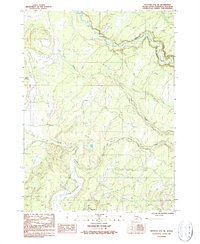
1987 Map of Seldovia D-5 NE
USGS Topo · Published 1987About this map
Deep Creek and the Chakok River define the drainage patterns of this Alaskan landscape on the western Kenai Peninsula. This 1987 provisional survey illustrates a vast network of Winter Trails and 4wd routes that cross the wetland-rich terrain between Stariski Creek and Clam Creek. The distribution of these trails reveals how the region was navigated during the colder months, avoiding the lower, swampy ground that characterizes the areas near Happy Creek. While the sheet shows no major permanent settlements, the intricate system of seasonal paths provides clear evidence of localized travel and land use in this specific interior portion of the peninsula.
Find a feature on this map
7 named features on this map. Tap any name to fly to it.
Don’t see what you’re looking for? This feature index may not catch every label — zoom into the map to look around manually.
Map Details
Editions of this 1987 Seldovia D-5 NE Map
This is the sole edition of this map. No revisions or reprints were ever made.
Other maps of this area

1944 · Kenai
USGS Topo · 1:250,000

1946 · Seldovia D-5
USGS Topo · 1:63,360

1949 · Seldovia D-4
USGS Topo · 1:63,360

1950 · Kenai
USGS Topo · 1:250,000

1951 · Seldovia D-5
USGS Topo · 1:63,360

1951 · Seldovia D-4
USGS Topo · 1:63,360

1951 · Seldovia
USGS Topo · 1:250,000

1951 · Kenai A-5
USGS Topo · 1:63,360

1951 · Kenai A-4
USGS Topo · 1:63,360

1952 · Kenai A-5
USGS Topo · 1:63,360