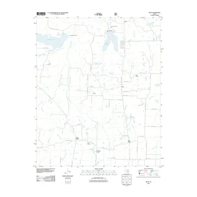
2010 Map of Selfs
USGS Topo · Published 2010About this map
Coffee Mill Lake and Lake Crockett dominate the northern landscape of this Fannin County quadrangle, where the waters of Sandy Creek and Bois d'Arc Creek are managed by the Coffee Mill Creek Dam and Lake Davy Crockett Dam. This 2010 survey illustrates a rural Texas environment defined by a dense network of county roads and several established small communities. Allens Chapel and Allen Point serve as southern landmarks, while the settlement of Selfs sits at a junction of local routes. For those researching family history in the area, the map provides precise locations for four rural burial grounds: Wilks Cemetery, Shiloh Cemetery, New Salem Cemetery, and the Allen Chapel Cemetery. The terrain is etched by numerous drainage systems, including Honey Grove Creek and Yoakum Creek, which feed into the larger creek basins.
Find a feature on this map
58 named features on this map. Tap any name to fly to it.
Don’t see what you’re looking for? This feature index may not catch every label — zoom into the map to look around manually.
Map Details
Editions of this 2010 Selfs Map
This is the sole edition of this map. No revisions or reprints were ever made.
Other maps of this area

1903 · Paris
USGS Topo · 1:125,000

1947 · Honey Grove
USGS Topo · 1:62,500

1948 · Direct
USGS Topo · 1:62,500

1949 · Direct
USGS Topo · 1:62,500

1949 · Honey Grove
USGS Topo · 1:62,500

1953 · Texarkana
USGS Topo · 1:250,000

1954 · Sherman
USGS Topo · 1:250,000

1956 · Texarkana
USGS Topo · 1:250,000

1957 · Wade
USGS Topo · 1:62,500

1958 · Bonham
USGS Topo · 1:62,500