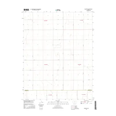
2016 Map of Selkirk SW
USGS Topo · Published 2016About this map
The high plains landscape of western Kansas is defined by the strict geometry of the Public Land Survey System along the border of Greeley Co and Hamilton Co. This 2016 survey illustrates the persistent grid of the agricultural frontier, where section lines dictate the path of travel through an arid, open expanse. Notable corridors like Co Rd 1993 and Co Rd EE trace the township lines of t20s r40w and t21s r39w, marking the boundaries between vast tracts of rangeland or cultivated fields. The absence of concentrated settlements emphasizes the rural character of the region, where infrastructure is limited to the essential network of county roads such as Co Rd BB and Co Rd 19. For the researcher, the map preserves the exact layout of land divisions and the naming conventions of the modern county road system in a sparsely populated corner of the state.
Find a feature on this map
31 named features on this map. Tap any name to fly to it.
Don’t see what you’re looking for? This feature index may not catch every label — zoom into the map to look around manually.
Map Details
Editions of this 2016 Selkirk SW Map
This is the sole edition of this map. No revisions or reprints were ever made.
Other maps of this area

1955 · Scott City
USGS Topo · 1:250,000

1958 · Scott City
USGS Topo · 1:250,000

1966 · Tribune 4 NW
USGS Topo · 1:24,000
1966 · Tribune 3 NE
USGS Topo · 1:24,000

1966 · Tribune 4 NE
USGS Topo · 1:24,000

1970 · Selkirk SW
USGS Topo · 1:24,000

1970 · Selkirk SE
USGS Topo · 1:24,000

1970 · Selkirk
USGS Topo · 1:24,000

1970 · Selkirk NW
USGS Topo · 1:24,000

1970 · Tribune SE
USGS Topo · 1:24,000