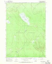
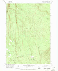
1967 Map of Sellers Marsh
USGS Topo · Published 1971About this map
The Winema National Forest landscape in northern Klamath County is defined by its high-elevation wetlands and volcanic geology. Centered on the broad expanse of Sellers Marsh, this 1967 field-checked survey illustrates a network of seasonal water sources and meadows including Round Meadow, Crooked Meadow, and Sproats Meadow. The presence of the Johnson Meadow Guard Sta and the Pumice Well indicate the importance of forest management and local resources in this remote terrain. To the south, Johnson Meadow sits near the drainage of Jack Creek, while the volcanic history of the region is evident in features like Pumice Flat and the prominent rise of Parker Butte. The map documents a moment when this area was primarily utilized for conservation and seasonal grazing, captured just before the 1970s.
Find a feature on this map
15 named features on this map. Tap any name to fly to it.
Don’t see what you’re looking for? This feature index may not catch every label — zoom into the map to look around manually.
Map Details
Editions of this 1967 Sellers Marsh Map
This is the sole edition of this map. No revisions or reprints were ever made.
Other maps of this area

1935 · Chemult
USGS Topo · 1:96,000

1941 · Chemult
USGS Topo · 1:125,000

1955 · Crescent
USGS Topo · 1:250,000

1957 · Crescent
USGS Topo · 1:250,000

1958 · Crescent
USGS Topo · 1:250,000
1967 · Walker Mtn
USGS Topo · 1:24,000
1967 · Crescent NE
USGS Topo · 1:24,000
1967 · Crescent
USGS Topo · 1:24,000

1968 · Location Butte
USGS Topo · 1:24,000
1968 · Sugarpine Mtn. NW
USGS Topo · 1:24,000