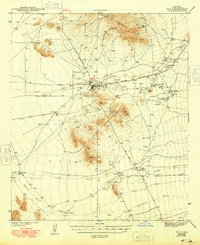
1943 Map of Sells
USGS Topo · Published 1948About this map
Sells serves as the central hub of this Arizona landscape, surveyed in the early 1940s when the region was primarily characterized by indigenous settlements and desert resource extraction. The map reveals a network of indigenous communities including Artesa, Ali Chuk Son, and Cowlic, often centered around vital water sources simply marked as Well or Tank. To the south, the San Solano Mission and Topawa P O indicate established religious and civic centers along the San Miguel Road. The northern portion of the map is dominated by the South Comobabi Mts, where several mining operations are located, such as the Green Mine and Midnite Mine. This era shows a transition in desert transportation, with the Ajo-Tucson Highway and a dedicated Landing Field providing connections across the desert floor toward the Artesa Mountains.
Find a feature on this map
32 named features on this map. Tap any name to fly to it.
Don’t see what you’re looking for? This feature index may not catch every label — zoom into the map to look around manually.
Map Details
Editions of this 1943 Sells Map
4 editions found

Other maps of this area

1934 · Silver Bell
USGS Topo · 1:125,000

1937 · Comobabi
USGS Topo · 1:48,000

1938 · San Vicente
USGS Topo · 1:62,500

1941 · Presumido Peak
USGS Topo · 1:62,500

1941 · San Vicente
USGS Topo · 1:62,500

1941 · Baboquivari Peak
USGS Topo · 1:62,500

1941 · Vamori
USGS Topo · 1:62,500

1941 · Sells
USGS Topo · 1:62,500

1942 · San Vicente
USGS Topo · 1:62,500

1942 · Comobabi
USGS Topo · 1:62,500