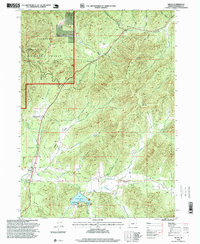
1996 Map of Selma
USGS Topo · Published 1999About this map
Selma sits at the nexus of several creek valleys in this mid-1990s record of Josephine County. The terrain transitions from the developed agricultural lands and county recreation areas surrounding Lake Selmac to the steep, forested slopes of the Siskiyou National Forest. Water is the primary sculptor of the landscape here, with Deer Creek, Mc Mullin Creek, and Thompson Creek converging in the lower elevations. The map documents significant local landmarks for genealogists and historians, including the Deer Creek Cemetery and the former location of Anderson Station. High points like Hayes Hill Summit and Wonder Mountain dominate the eastern and northern horizons, while the small settlement of Dryden anchors the southeastern portion of the quadrangle. Several quarries are noted throughout the hills, indicating the local extraction history of the region.
Find a feature on this map
38 named features on this map. Tap any name to fly to it.
Don’t see what you’re looking for? This feature index may not catch every label — zoom into the map to look around manually.
Map Details
Editions of this 1996 Selma Map
This is the sole edition of this map. No revisions or reprints were ever made.
Other maps of this area

1908 · Grants Pass
USGS Topo · 1:125,000

1917 · Kerby
USGS Topo · 1:125,000

1918 · Kerby
USGS Topo · 1:125,000

1945 · Kerby
USGS Topo · 1:125,000

1954 · Cave Junction
USGS Topo · 1:62,500

1954 · Oregon Caves
USGS Topo · 1:62,500

1954 · Selma
USGS Topo · 1:62,500

1954 · Grants Pass
USGS Topo · 1:62,500

1955 · Medford
USGS Topo · 1:250,000

1957 · Medford
USGS Topo · 1:250,000