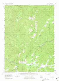
1954 Map of Selma
USGS Topo · Published 1981About this map
Selma and the Illinois River valley dominate this mid-century portrait of southern Josephine County. The map documents a landscape defined by small roadside settlements and a legacy of extraction, where the Redwood Highway connects communities like Dryden, Wonder, and Love Station. The survey illustrates a shift in land use, noting the Spaulding Mill (Site) and various mining operations such as the Eureka Mine and Ramsey Mine scattered throughout the surrounding heights of Onion Mtn and Eight Dollar Mtn. Local family history is grounded in features like the Deer Creek Cemetery and the Grange Hall near Dryden. The network of Jeep Trail routes and creek crossings, including Deer Creek and Briggs Creek, reveals the intricate access points used for logging and mining throughout the Siskiyou National Forest.
Find a feature on this map
87 named features on this map. Tap any name to fly to it.
Don’t see what you’re looking for? This feature index may not catch every label — zoom into the map to look around manually.
Map Details
Editions of this 1954 Selma Map
4 editions found

Other maps of this area

1904 · Riddle
USGS Topo · 1:125,000

1908 · Grants Pass
USGS Topo · 1:125,000

1917 · Kerby
USGS Topo · 1:125,000

1918 · Kerby
USGS Topo · 1:125,000

1945 · Kerby
USGS Topo · 1:125,000

1946 · Galice
USGS Topo · 1:62,500

1948 · Galice
USGS Topo · 1:62,500

1954 · Cave Junction
USGS Topo · 1:62,500

1954 · Oregon Caves
USGS Topo · 1:62,500

1954 · Marial
USGS Topo · 1:62,500