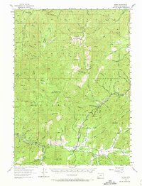
1954 Map of Selma
USGS Topo · Published 1973About this map
Selma sits at the heart of this mid-century survey, positioned where the Redwood Highway crosses the valley floor within the Siskiyou National Forest. The landscape is defined by its deep mining and timber heritage, evidenced by the numerous specialized sites such as Chrome Camp, the Spaulding Mills (Site), and several prospect operations including the Barr Mine and Eureka Mine. Travel through the area followed a network of specialized routes like Reeves Rd, McMullin Rd, and various jeep trails that connected isolated stations and flats.
Find a feature on this map
107 named features on this map. Tap any name to fly to it.
Don’t see what you’re looking for? This feature index may not catch every label — zoom into the map to look around manually.
Map Details
Editions of this 1954 Selma Map
4 editions found

Other maps of this area

1904 · Riddle
USGS Topo · 1:125,000

1908 · Grants Pass
USGS Topo · 1:125,000

1917 · Kerby
USGS Topo · 1:125,000

1918 · Kerby
USGS Topo · 1:125,000

1945 · Kerby
USGS Topo · 1:125,000

1946 · Galice
USGS Topo · 1:62,500

1948 · Galice
USGS Topo · 1:62,500

1954 · Cave Junction
USGS Topo · 1:62,500

1954 · Oregon Caves
USGS Topo · 1:62,500

1954 · Marial
USGS Topo · 1:62,500