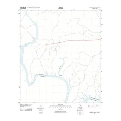
2010 Map of Seminole Canyon
USGS Topo · Published 2010About this map
The Rio Grande forms the international boundary between the United States and Mexico in this arid borderland survey. This map illustrates the convergence of major waterways within the Amistad Reservoir, where the Pecos River joins the primary river channel. The landscape is defined by deep incisions like Seminole Canyon, which carves through the limestone terrain toward the reservoir's edge. Human presence in this frontier region is largely confined to infrastructure and ranching access, evidenced by the transit of Zubenbueler Ranch Rd. The survey provides a clear view of the water levels and shoreline configuration of the reservoir as it appeared in the early 21st century, illustrating how the dammed waters have transformed the original canyons and river bends of the border.
Find a feature on this map
6 named features on this map. Tap any name to fly to it.
Don’t see what you’re looking for? This feature index may not catch every label — zoom into the map to look around manually.
Map Details
Editions of this 2010 Seminole Canyon Map
This is the sole edition of this map. No revisions or reprints were ever made.
Other maps of this area

1941 · Feely
USGS Topo · 1:62,500

1943 · Shumla
USGS Topo · 1:62,500

1944 · Mouth Of Pecos
USGS Topo · 1:62,500

1944 · Baker Crossing
USGS Topo · 1:62,500

1958 · Del Rio
USGS Topo · 1:250,000

1964 · Del Rio
USGS Topo · 1:250,000
1972 · Zuberbueler Bend NW
USGS Topo · 1:24,000

1972 · Seminole Canyon
USGS Topo · 1:24,000
1972 · Zuberbueler Bend
USGS Topo · 1:24,000
1972 · Box Canyon
USGS Topo · 1:24,000