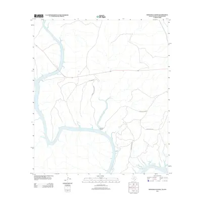
2013 Map of Seminole Canyon
USGS Topo · Published 2013About this map
Amistad Reservoir dominates this borderland landscape where the Rio Grande carves through the limestone of the Chihuahuan Desert. This 2013 survey illustrates the complex geography of the international boundary, highlighting the flooded canyons and protected lands that define the region. Cultural and recreational preservation is central to the area, evidenced by the presence of Seminole Canyon State Park and the expansive Amistad Ntl Rec Area. The map details the intricate fingers of the reservoir as they reach into side drainages like Seminole Canyon and Pink Cave Cove. Transportation in this arid environment is limited to significant corridors such as US Highway 90 and local access routes including State Park Rd 67 and Zubenbueler Ranch Rd, which provide the only terrestrial links through this river-cut terrain.
Find a feature on this map
9 named features on this map. Tap any name to fly to it.
Don’t see what you’re looking for? This feature index may not catch every label — zoom into the map to look around manually.
Map Details
Editions of this 2013 Seminole Canyon Map
This is the sole edition of this map. No revisions or reprints were ever made.
Other maps of this area

1941 · Feely
USGS Topo · 1:62,500

1943 · Shumla
USGS Topo · 1:62,500

1944 · Mouth Of Pecos
USGS Topo · 1:62,500

1944 · Baker Crossing
USGS Topo · 1:62,500

1958 · Del Rio
USGS Topo · 1:250,000

1964 · Del Rio
USGS Topo · 1:250,000
1972 · Zuberbueler Bend NW
USGS Topo · 1:24,000

1972 · Seminole Canyon
USGS Topo · 1:24,000
1972 · Zuberbueler Bend
USGS Topo · 1:24,000
1972 · Box Canyon
USGS Topo · 1:24,000