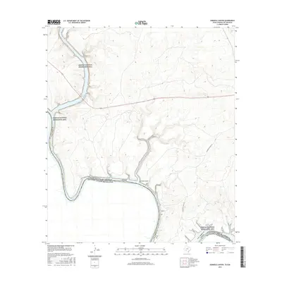
2016 Map of Seminole Canyon
USGS Topo · Published 2016About this map
Amistad Reservoir dominates this borderland landscape where the Pecos River and Rio Grande converge. The topography is defined by the dramatic incision of Seminole Canyon and the backwater reaches of Pink Cave Cove, reflecting the complex hydrology of the Rio Grande basin along the United States and Mexico border. While much of the land is preserved within the Amistad National Recreation Area, traces of regional ranching history persist in the form of Zubenbueler Ranch Rd. This 2016 survey illustrates the modern contours of the international boundary and the recreational development of this arid river environment in Val Verde County.
Find a feature on this map
12 named features on this map. Tap any name to fly to it.
Don’t see what you’re looking for? This feature index may not catch every label — zoom into the map to look around manually.
Map Details
Editions of this 2016 Seminole Canyon Map
This is the sole edition of this map. No revisions or reprints were ever made.
Other maps of this area

1941 · Feely
USGS Topo · 1:62,500

1943 · Shumla
USGS Topo · 1:62,500

1944 · Mouth Of Pecos
USGS Topo · 1:62,500

1944 · Baker Crossing
USGS Topo · 1:62,500

1958 · Del Rio
USGS Topo · 1:250,000

1964 · Del Rio
USGS Topo · 1:250,000
1972 · Zuberbueler Bend NW
USGS Topo · 1:24,000

1972 · Seminole Canyon
USGS Topo · 1:24,000
1972 · Zuberbueler Bend
USGS Topo · 1:24,000
1972 · Box Canyon
USGS Topo · 1:24,000