
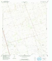
1970 Map of Seminole SE
USGS Topo · Published 1973About this map
The West Texas plains at the Gaines and Andrews County line reveal an industrial landscape defined by the mid-century petroleum economy. Within the Means North Field and Nolley Oil Field, the terrain is marked by a dense network of extraction infrastructure including numerous Oil Wells, a Drill Hole, and a Pumping Sta. This 1970 snapshot illustrates how resource extraction dictated the local geography, where utility corridors like the Pipeline and Telephone Road cut across the arid landscape. Social and transportation amenities are sparse but functional, represented by a Radio Tower and Roadside Parks along the primary north-south thoroughfare. The presence of several Gravel Pits further emphasizes the map's focus on material production and the maintenance of the region's roadway infrastructure during this era of intensive energy development.
Find a feature on this map
11 named features on this map. Tap any name to fly to it.
Don’t see what you’re looking for? This feature index may not catch every label — zoom into the map to look around manually.
Map Details
Editions of this 1970 Seminole SE Map
2 editions found
Other maps of this area

1954 · Hobbs
USGS Topo · 1:250,000

1958 · Hobbs
USGS Topo · 1:250,000

1969 · Seminole SW
USGS Topo · 1:24,000

1970 · Seminole NE
USGS Topo · 1:24,000

1970 · Cedar Point Ranch
USGS Topo · 1:24,000

1970 · McKenzie Lake NW
USGS Topo · 1:24,000

1970 · Seminole
USGS Topo · 1:24,000

1971 · Five Wells Ranch NW
USGS Topo · 1:24,000

1971 · Florey
USGS Topo · 1:24,000

1971 · Shafter Lake
USGS Topo · 1:24,000