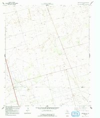
1970 Map of Seminole SE
USGS Topo · Published 1991About this map
Means North Oil Field dominates this West Texas landscape, showing the industrial infrastructure of the Permian Basin at the start of the 1970s. The map illustrates a dense network of energy extraction features across the undulating plains, including numerous Oil Wells, a Pumping Sta, and a significant Pipeline corridor. This era was marked by established production, evidenced by the transition from active drilling to a steady grid of wells and support structures. Along the southern edge, the Gaines Co and Andrews Co line marks a political boundary through the heart of the oil country. Transport and communication are represented by the aptly named Telephone Road and local Roadside Parks, while scattered Gravel Pits and a Radio Tower point to the necessary materials and connectivity required to maintain these remote operations.
Find a feature on this map
10 named features on this map. Tap any name to fly to it.
Don’t see what you’re looking for? This feature index may not catch every label — zoom into the map to look around manually.
Map Details
Editions of this 1970 Seminole SE Map
2 editions found
Other maps of this area

1954 · Hobbs
USGS Topo · 1:250,000

1958 · Hobbs
USGS Topo · 1:250,000

1969 · Seminole SW
USGS Topo · 1:24,000

1970 · Seminole NE
USGS Topo · 1:24,000

1970 · Cedar Point Ranch
USGS Topo · 1:24,000

1970 · McKenzie Lake NW
USGS Topo · 1:24,000

1970 · Seminole SE
USGS Topo · 1:24,000

1970 · Seminole
USGS Topo · 1:24,000

1971 · Five Wells Ranch NW
USGS Topo · 1:24,000

1971 · Florey
USGS Topo · 1:24,000