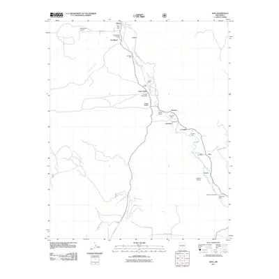
2011 Map of Sena
USGS Topo · Published 2011About this map
The San Miguel del Vado Historic District anchors the northern reaches of this Pecos River valley corridor, where early 21st-century topography shows a persistent pattern of river-fronting settlements. Moving downstream, the landscape transitions through a sequence of small agricultural communities including Ribera, San Miguel, Upper Pueblo, and Lower Pueblo. The water of the Pecos River is heavily managed for local irrigation and use, evidenced by a dense concentration of infrastructure such as the Pueblo Dam, Garanbuio Dam, and Villanueva Dam.
Find a feature on this map
36 named features on this map. Tap any name to fly to it.
Don’t see what you’re looking for? This feature index may not catch every label — zoom into the map to look around manually.
Map Details
Editions of this 2011 Sena Map
This is the sole edition of this map. No revisions or reprints were ever made.
Other maps of this area

1890 · Bernal
USGS Topo · 1:125,000

1891 · Bernal
USGS Topo · 1:125,000

1894 · Bernal
USGS Topo · 1:125,000

1894 · Lamy
USGS Topo · 1:125,000

1954 · Santa Fe
USGS Topo · 1:250,000

1958 · Santa Fe
USGS Topo · 1:250,000

1960 · Villanueva
USGS Topo · 1:62,500

1963 · Aurora
USGS Topo · 1:24,000
1963 · San Juan
USGS Topo · 1:24,000
1966 · Laguna Ortiz
USGS Topo · 1:24,000