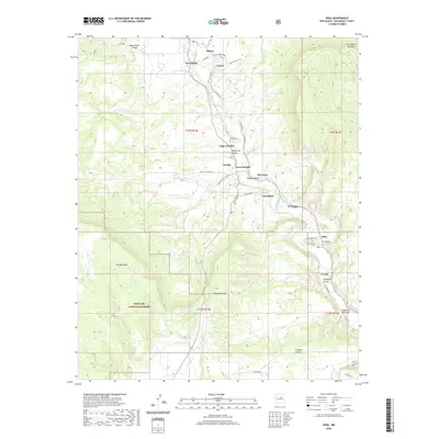
2020 Map of Sena
USGS Topo · Published 2020About this map
The Pecos River carves a winding path through this portion of San Miguel County, anchoring a string of traditional high-desert settlements. These communities, including Sena, Ribera, and San Miguel, are situated along the river valley where the terrain transitions from the high elevations of Hurtado Mesa and Mesa Sacatosa to the fertile bottomlands. The map reveals a distinct settlement pattern of clustered villages such as Upper Pueblo, Pueblo, and Lower Pueblo, often connected by a network of rural roads like Coruco Rd and Garanbuio Rd. Genealogists may find interest in the Pueblo Cem located near the riverbank. Significant portions of the southwestern quadrant are protected within the Santa Fe National Forest, while various arroyos, such as Arroyo de Chamizal and Gonzales Arroyo, mark the drainage patterns across the rugged canyons and mesas.
Find a feature on this map
46 named features on this map. Tap any name to fly to it.
Don’t see what you’re looking for? This feature index may not catch every label — zoom into the map to look around manually.
Map Details
Editions of this 2020 Sena Map
This is the sole edition of this map. No revisions or reprints were ever made.
Other maps of this area

1890 · Bernal
USGS Topo · 1:125,000

1891 · Bernal
USGS Topo · 1:125,000

1894 · Bernal
USGS Topo · 1:125,000

1894 · Lamy
USGS Topo · 1:125,000

1954 · Santa Fe
USGS Topo · 1:250,000

1958 · Santa Fe
USGS Topo · 1:250,000

1960 · Villanueva
USGS Topo · 1:62,500

1963 · Aurora
USGS Topo · 1:24,000
1963 · San Juan
USGS Topo · 1:24,000
1966 · Laguna Ortiz
USGS Topo · 1:24,000