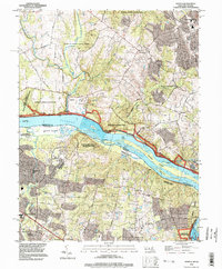
1994 Map of Seneca
USGS Topo · Published 1998About this map
The Potomac River serves as the dominant spine of this 1994 landscape, where the historical border between Maryland and Virginia is defined by a complex network of islands and navigation structures. Significant local heritage is preserved along the northern bank within the Chesapeake and Ohio Canal National Historical Park, where several numbered locks like Lock 24 and Lock 23 remain as evidence of early transit. Settlements such as Darnestown, Seneca, and Rushville anchor the Maryland side, while Lowes Island and Dranesville define the Virginia interior. The transition from established community to protected conservation land is clear, with large tracts dedicated to Seneca Creek State Park and Blockhouse Point Park. Genealogists and local historians can find specific family-history markers such as Leighs Cem and the Dranesville Tavern Park near the crossroads of the southern landscape.
Find a feature on this map
62 named features on this map. Tap any name to fly to it.
Don’t see what you’re looking for? This feature index may not catch every label — zoom into the map to look around manually.
Map Details
Editions of this 1994 Seneca Map
This is the sole edition of this map. No revisions or reprints were ever made.
Other maps of this area

1890 · Mt. Vernon
USGS Topo · 1:125,000

1891 · Mt. Vernon
USGS Topo · 1:125,000

1893 · Frederick
USGS Topo · 1:125,000

1894 · Frederick
USGS Topo · 1:125,000

1894 · Mt. Vernon
USGS Topo · 1:125,000

1897 · Mt. Vernon
USGS Topo · 1:125,000

1900 · Washington
USGS Topo · 1:62,500

1908 · Rockville
USGS Topo · 1:62,500

1908 · Seneca
USGS Topo · 1:62,500

1915 · Fairfax
USGS Topo · 1:62,500