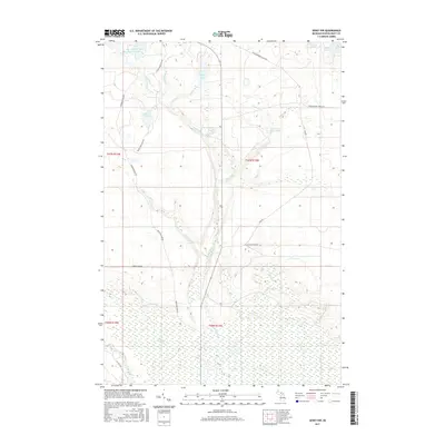
2017 Map of Seney NW
USGS Topo · Published 2017About this map
The Fox River and its intricate drainage network dominate this section of the Upper Peninsula, defined by the low-lying wetlands of The Spreads and the broad expanse of the Danaher Plains. This survey illustrates a landscape shaped by water management and natural hydrology, featuring The Reservoir in the northwest and numerous small water bodies such as Dutch Fred Lake, Snyder Lake, and Carpenter Lake. The transition from the more stable ground of the plains to the braided channels of the E Br Fox River suggests a wilderness area primarily utilized for resource management and seasonal recreation. Local transport is facilitated by a network of specialized routes including the Tahquamenon Truck Trl, Reservoir Dam Rd, and Star Rd, which connect remote hunting and fishing spots like the Clear Creek Trout Pond and Kings Pond.
Find a feature on this map
29 named features on this map. Tap any name to fly to it.
Don’t see what you’re looking for? This feature index may not catch every label — zoom into the map to look around manually.
Map Details
Editions of this 2017 Seney NW Map
This is the sole edition of this map. No revisions or reprints were ever made.
Other maps of this area

1931 · Seney SW
USGS Topo · 1:31,680

1931 · Seney NW
USGS Topo · 1:31,680

1931 · Driggs Lake NE
USGS Topo · 1:31,680

1931 · Seney SE
USGS Topo · 1:31,680

1931 · Driggs Lake SE
USGS Topo · 1:31,680

1954 · Sault Sainte Marie
USGS Topo · 1:250,000

1956 · Sault Sainte Marie
USGS Topo · 1:250,000

1957 · Sault Sainte Marie
USGS Topo · 1:250,000

1958 · Sault Sainte Marie
USGS Topo · 1:250,000

1958 · Marquette
USGS Topo · 1:250,000