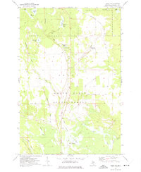
1972 Map of Seney NW
USGS Topo · Published 1975About this map
The Grand Sable State Forest dominates this Schoolcraft County landscape, revealing a wilderness managed for both conservation and historical utility in the early 1970s. The map traces the winding course of the East Branch Fox River as it moves south toward a braided wetland area known as The Spreads. This river system is supported by numerous tributaries and man-made features like The Reservoir and Kings Pond, indicating a carefully monitored watershed.
Find a feature on this map
35 named features on this map. Tap any name to fly to it.
Don’t see what you’re looking for? This feature index may not catch every label — zoom into the map to look around manually.
Map Details
Editions of this 1972 Seney NW Map
This is the sole edition of this map. No revisions or reprints were ever made.
Other maps of this area

1931 · Seney SW
USGS Topo · 1:31,680

1931 · Seney NW
USGS Topo · 1:31,680

1931 · Driggs Lake NE
USGS Topo · 1:31,680

1931 · Seney SE
USGS Topo · 1:31,680

1931 · Driggs Lake SE
USGS Topo · 1:31,680

1954 · Sault Sainte Marie
USGS Topo · 1:250,000

1956 · Sault Sainte Marie
USGS Topo · 1:250,000

1957 · Sault Sainte Marie
USGS Topo · 1:250,000

1958 · Sault Sainte Marie
USGS Topo · 1:250,000

1958 · Marquette
USGS Topo · 1:250,000