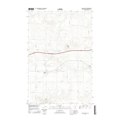
2014 Map of Sentinel Butte
USGS Topo · Published 2014About this map
Sentinel Butte stands as a prominent geographic anchor in this Golden Valley County landscape, where the high plains of western North Dakota transition through sharp coulees and plateaus. This 2014 survey captures the township of Sentinel Butte and the smaller settlement of De Mores to the east, connected by a network of county roads like CR-1728 and CR-1711. The rugged topography is defined by significant landmarks such as Camels Hump Butte and its namesake Camels Hump Lake, while drainage systems like Knutson Cr and Andrews Cr carve through the elevation. Local history is grounded in sites like Saint Michaels Cem, located north of the primary townsite. The layout of the modern transportation grid, including Red Hills Rd and Square Butte Rd, illustrates how the rural infrastructure navigates the complex terrain of the Missouri Plateau.
Find a feature on this map
28 named features on this map. Tap any name to fly to it.
Don’t see what you’re looking for? This feature index may not catch every label — zoom into the map to look around manually.
Map Details
Editions of this 2014 Sentinel Butte Map
This is the sole edition of this map. No revisions or reprints were ever made.
Other maps of this area

1953 · Dickinson
USGS Topo · 1:250,000

1953 · Watford City
USGS Topo · 1:250,000

1957 · Dickinson
USGS Topo · 1:250,000

1957 · Watford City
USGS Topo · 1:250,000

1967 · Watford City
USGS Topo · 1:250,000

1974 · West Twin Butte
USGS Topo · 1:24,000
1974 · Hootowl Creek SW
USGS Topo · 1:24,000

1974 · Wannagan Creek West
USGS Topo · 1:24,000

1979 · Sentinel Butte SE
USGS Topo · 1:24,000
1979 · Buffalo Gap Campground
USGS Topo · 1:24,000